
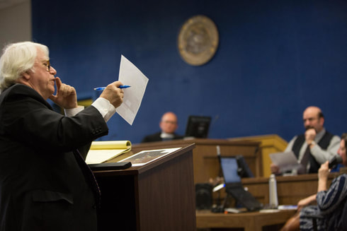
 On March 13 and again on March 21, 2018, Bill DePaulo, Counsel to KOTM, appeared in the Circuit Court of Monroe County, West Virginia as counsel for one of the alleged "tree-sitters" ensconced in trees purportedly blocking MVP's ability to clear trees along the path of the 303-mile natural gas pipeline. The point of contention was at a spot in the Jefferson National Forest where the MVP would intersect with the Appalachian National Scenic Trail (ANST, the priceless national treasure running from Georgia to Maine). According to the FERC that licensed MVP's construction, MVP was required to leave a 300 foot buffer on either side of the Appalachian Trail and tunnel underneath it as a means of minimizing the impact of the 42" natural gas pipeline on the ANST. Effectively, there was a 600 foot long "NO CUT" zone extending across the width of the ANST, 300 feet on either side. MVP failed in its effort to obtain an injunction against the tree-sitters because, on cross examination, their surveyor could not reliably prove that the tree-sitters were, as MVP alleged, 7 feet beyond the NO CUT zone. As explained in National Public Radio's coverage of the hearing: At the center of the courtroom debate was a map, provided by MVP, showing the location of pipeline mile markers, the Appalachian National Scenic Trail and the tree sitters in Jefferson National Forest. The Federal Energy Regulatory Commission, known as FERC, has granted MVP permission to cut trees up to the pipeline’s mile marker 196.29. But exactly where is mile marker 196.29? Defense attorney William DePaulo went through the map item by item, defining points, adding numbers and to reveal that some points had been rounded. Then he pulled out a piece of paper in what he called a “6th grade” measuring tool to demonstrate items on the map were not located to scale during his cross examination of MVP expert witness, Marshall W. Robinson. DePaulo, pressed the paper to the map, “Put the left corner at 196.35 and go up to 196.4 they are not the same distance are they,” he asked. “No, they’re not,” responded Robinson. Defense attorney William DePaulo cross examines expert witness Marshall Robinson about the surveyed map presented as evidence in the case. CREDIT NANCY ANDREWS DePaulo then turned to the judge, “And that’s 5/100ths of a mile. And we know that 196.35 and 196.4 is also 5/100ths of a mile. And it should be, if the map is to scale, it oughta be the same thing. But it clearly is not,” DePaulo concluded. Judge Irons described himself as “flabbergasted.” “The devil’s in the details,” he said. “I have a map that it seemed pretty clear at first blush and then the more we listened to it there are rounding errors, there’s inconsistencies. As I sit here I really don’t know whether or not it’s right.” Judge Robert A. Irons of the Monroe County Circuit Court ultimately ruled that MVP had not carried the burden of proof necessary to obtain a preliminary injunction, and denied MVP's requested order to remove the tree-sitters. In the time the tree-sitters on Peter's Mountain were in place three more sits began on the Virginia side of the Appalachian Trail. MVP's efforts to evict those tree-sitters has had inconsistent success, with tree-sitters in one location voluntarily vacating a given tree subject to an injunction, for another still free of MVP. And there are a lot of trees spread out over the proposed 303-mile MVP pipeline. 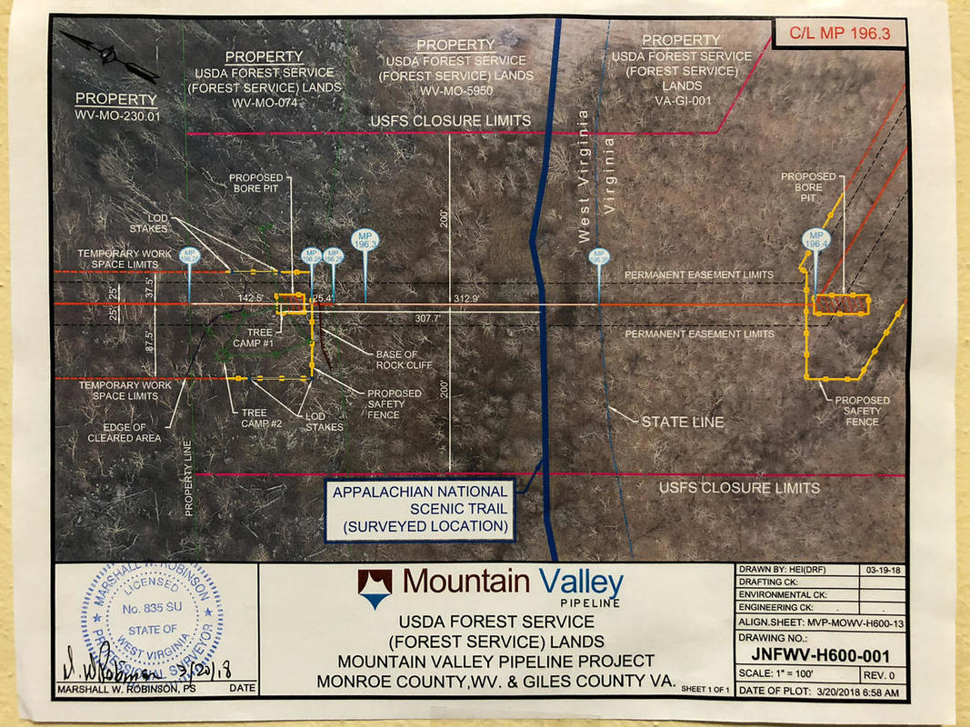
1 Comment
|
AuthorWrite something about yourself. No need to be fancy, just an overview. Archives
August 2019
Categories |
 RSS Feed